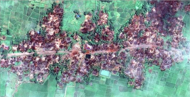
New satellite imagery shows several hundred buildings burned in Burma’s Rakhine State, Human Rights Watch said today. Imagery from the Rohingya Muslim village of Chein Khar Li in Rathedaung township shows 700 buildings burned, a near total destruction of the village.
The Burmese government should urgently grant access to independent monitors to determine the sources of fires and assess allegations of serious human rights violations made by ethnic Rohingya refugees who have fled into neighboring Bangladesh.
“This new satellite imagery shows the total destruction of a Muslim village, and prompts serious concerns that the level of devastation in northern Rakhine State may be far worse than originally thought,” said Phil Robertson, deputy Asia director. “Yet this is only one of 17 sites that we’ve located where burnings have taken place. Independent monitors are needed on the ground to urgently uncover what’s going on.”
Human Rights Watch identified a total of 700 destroyed buildings in Chein Khar Li from an analysis of satellite imagery recorded on August 31, 2017. The imagery shows that 99 percent of the village was destroyed. Damage signatures are consistent with fire, including the presence of large burn scars and destroyed tree cover.
This imagery builds on previously published data collected by Human Rights Watch indicating burnings taking place at 17 separate sites across northern Rakhine state between August 25 and 30, 2017. Those burnings followed a series of coordinated attacks by ethnic Rohingya militants of the Arakan Rohingya Salvation Army (ARSA) on the morning of August 25, 2017 against dozens of Burmese government police stations and checkpoints, government offices, and an army base.u
Satellites initially detected active fires in the early afternoon of August 25 in the village tract of Koe Tan Kauk in Rathedaung township, where Chein Khar Li is located. There are two adjacent villages located north and south of Chein Khar Li (Muslim village) that appeared intact in the satellite imagery—Koe Tan Kaung and Chein Khar Li (an ethnic Rakhine-populated village with the same formal name as the destroyed village).
Human Rights Watch analysis indicates that the large areas shown as burnt in the satellite imagery means it is very likely the burning was deliberate.
Given the current monsoon weather conditions in Rakhine State, it would have been very difficult to set fire to such a significant number of buildings. The scale of the fire destruction suggests that burnings either were done with significant numbers of people or over a significant period of time to carry out this widespread degree of burning.
The Burmese government has blamed the setting of fires on ARSA militants and Rohingya villagers who the government claims set fire to their own homes. The government has not provided any evidence to support these allegations, nor did they ever prove similar allegations made by the government during the burning of Rohingya areas between October 2016 and December 2016. Human Rights Watch and others determined that Burmese security forces deliberately set those fires
Numerous Rohingya refugees who had recently fled from various other villages in northern Rakhine State to Bangladesh told Human Rights Watch that Burmese soldiers and police had burned down their homes and carried out armed attacks on villagers. Many of these Rohingya refugees suffered from recent bullet and shrapnel wounds.
The Burmese government should immediately grant visas to the three commissioners of the Fact Finding Mission appointed by the United Nations Human Rights Council.
“These new satellite images show exactly why it is critical for international investigators to be allowed on the ground in Rakhine State,” Robertson said. “The UN Fact Finding Mission should get the full cooperation of the Burmese government to fulfill their mandate to assess human rights abuses in Rakhine State and explore ways to end attacks and ensure accountability.”


